Quick Capture GIS Features and Assets Using GNSS
You can quick capture GIS feature and asset data using your GNSS position.
 NOTE: If an external GNSS receiver is not connected, the location is captured based on your device's internal GPS. SeeConnect to the GNSS Receiver for more information on connecting a GNSS receiver and ensuring the most accurate capture.
You can capture a point location for a GIS feature or asset.
- Tap the Add icon.
The Add panel opens.
- Select Asset and add an asset.
- From the General page for the new asset, tap the Menu icon.
- Tap Location.
- Tap Capture.
![]()
The GNSS location is captured. Once the location is captured, relevant GNSS metadata fields (e.g., accuracy, fix type, date/time) are automatically saved and populated.
You can capture a point with accuracy using the My Location icon.
- On the Location page for your asset or work activity, tap Map.
The Capture Location panel opens to your current location on the map.
- Tap the My Location icon to lock the map to your orientation. See Follow My Orientation in the View My Location on the Map topic for more information.
The map rotates relative to your change in direction and the Compass icon appears under the My Location icon, displaying the current direction and where North is relative to your orientation.
- Tap Add Point.
A message appears stating the point was added with accuracy, along with metadata details.
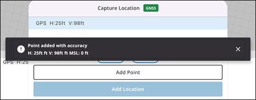
- Tap Add Location.
The Location is added and you are brought back to the Location page, where related metadata fields are automatically saved and populated.