Print the Map

The current view of the map can be exported and then printed. There are three tabs: Layout, Map only, and Exports. The Layout tab allows you to export the map extent with an author, copyright, legend, and north arrow. The Map only tab allows you to export and print just the map extent and source attributions. The Exports tab allows you to view the view of the map you exported.

PREREQUISITES:

  • The print service must be added as a service resource in Admin under GISGIS Services, and that service resource must be added to the service definition that the user is in. See Add Services to a Service Definition in the Admin Guide for Trimble Unity Maintain and Trimble Unity Permit for more information.
  • The Spatial Reference preference must be set in Admin on the Preferences page. See Configure Map Preferences in the Admin Guide for Trimble Unity Maintain and Trimble Unity Permit for more information.
  • The Map Image Output Pixel Size preference must be set in Admin on the Preferences page. See Configure Map Preferences in the Admin Guide for Trimble Unity Maintain and Trimble Unity Permit for more information.
  • The Map Image Buffer Distance for X and Y preference must be set in Admin on the Preferences page. See Configure Map Preferences in the Admin Guide for Trimble Unity Maintain and Trimble Unity Permit for more information.
  • There must be at least one map set up at the domain level.
  • You must be using ArcGIS 10.1 SP1 or higher.
  1. Click Printing in the map toolbar.
  2. Select which tab to use. Depending on the tab you use, different fields appear.
  3. Enter information in the tab. See Printing Fields for more information on these fields.

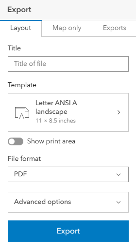
  1. Click Export to export the map and print.