Edit GIS Feature and Asset Data
You can edit asset details and update GIS feature attributes, making real-time adjustments to enhance data reliability and confirm accurate field data conditions. This feature works with maps available online or offline.
- From the map, select and open an asset to view the Asset Details screen. See Select Assets on the Map and Search For Assets in the Work Activity List for more information.
- Tap Edit.
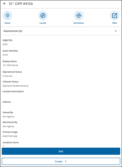
- Tap Attachments to view existing attachments or add new attachments to it. For more details on adding attachments, see Add Attachments.
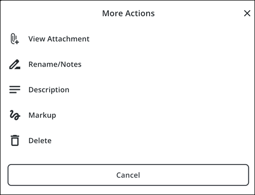
The More Actions menu opens and the following options are available:
- View Attachment: Tap to view the attachment.
- Done: Tap the attachment and tap Done to exit viewing.
- Rename/Notes: Tap to rename the attachment or add a note.
- X icon: Tap to remove the current attachment name.
- Tap the field to enter a new name or add a note.
- Rename: Tap to save the new attachment name.
- Description: Tap to add a description.
- Tap the field to enter a description.
- Update: Tap to update the description.
- Markup: Tap to use markup tools to mark the image with annotations.
- Color picker icon: Tap to change the markup color.
- Draw on the attachment to mark it up.
- Undo: Tap to undo the markup.
- Save: Tap to save the markup.
- Delete: Tap to delete the attachment.
- Tap a field and edit as desired.
- Tap Save.
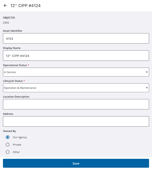
A message appears confirming the changes were successfully saved. Any changes are synced with the GIS database during the next automatic or manual syncing cycle.
- Tap a work activity.
- Tap Associated Assets.
Any assets associated with the work activity appear in the list.
- Tap an associated asset.
|
|
 NOTE: If an associated asset is unavailable in the currently active web map or offline map area, certain actions (e.g. Take Action, Map icon) are unavailable. Tapping the asset card displays an error message instead of opening the Asset Details page.
 - Tap Take Action.
- Tap Edit.
- Tap a field and edit as desired.
- Tap Save.
A message appears confirming the changes were successfully saved. Any changes are synced with the GIS database during the next automatic or manual syncing cycle.
See Remove an Asset from a Work Activity for more information on how to remove an asset from a work activity.
While in Edit mode, you can update GIS feature and asset data.
- While editing an asset from the map or an associated asset, tap the Menu icon.
- Tap Location. The following options are available from the Location page:
- Capture: Tap to capture the work activity location. See Quick Capture GIS Features and Assets Using GNSS for more information.
- Map: Tap to select a location on the map. See Manually Digitize GIS Features and Assets from the Map for more information.
- Clear: Tap to clear the selected location.
- Details: Tap to view location details.

